Hydrologic Summary
Streams
For several types of streams and other flowing water features, AgSite reports list their presence throughout a selected land tract as length in feet. The U.S. Geologic Survey defines a stream as a water body that flows naturally during at least a portion of the year, and it further categorizes streams based on factors such as water carrying frequency, source of the water that they carry and construction.
- Perennial stream: A perennial stream generally carries water throughout the year. This may not be true during severe drought conditions, however. Water flowing in perennial streams originates from smaller upstreams, groundwater sources and precipitation runoff.
- Intermittent stream: Intermittent streams, otherwise known as seasonal streams, don’t as consistently carry water. Generally, they contain water during periods when water flows from upstream and the groundwater supplies adequate water to flow. Precipitation runoff supplements the upstream flow and groundwater. When weather patterns turn dry, intermittent streams may lack flowing surface water.
- Canal or ditch: As an artificial water feature, meaning that it doesn’t occur naturally, a general canal or ditch exists to move water, irrigate or drain land, link at least two water bodies or provide a passage for watercraft to move.
- Pipelines carrying water: The pipelines measured by AgSite are closed conduits designed to carry water. They operate by using pumps, valves and control devices.
- Other streams: Stream feet included in the “other streams” category are for streams that are not included in the previous categories and that lack further classification. An ephemeral stream would be an example of an “other stream.”
Persons who own property with streams exposure should understand the responsibilities associated with managing those streams and adhering to the necessary regulations. If this AgSite report indicates any streams, it would be advisable to request a “jurisdictional determination” from the Army Corp of Engineers before making changes to the landscape. If this AgSite report does not indicate a stream, it does not necessarily mean that the Clean Water Rule does not apply to this land.
Sources and Other Resources:
- U.S. Environmental Protection Agency, Impaired Waters and Total Maximum Daily Loads
- USGS, Hydrography Standards and Specifications
- USGS, Water Science Glossary of Terms
Water Bodies
The AgSite report differentiates water bodies as rivers, lakes and ponds, swamps and marshes and other water bodies. Their physical attributes and other features distinguish one type of water body from another. The following definitions clarify differences among the water bodies reported in AgSite. The AgSite report measures these water features by area in acres.
- Rivers: Rivers capitalize on gravity moving water from high altitudes to lower altitudes. Water flowing in rivers may originate from precipitation runoff or groundwater. Groundwater forms when precipitation trickles below the Earth’s surface. At levels lower than the water table, water can saturate the ground. River banks can tap into the groundwater, and when they do, groundwater can enter into the river’s flow.
- Lakes and ponds: Generally, lakes and ponds take two different forms. First, they include standing water bodies shaped by natural shorelines and surrounded by land. Second, they include dammed flooded river systems designed to retain water. Lakes and ponds may be designated by name.
- Swamps and marshes: Water saturates swamps and marshes for much of a given year. These areas don’t undergo cultivation, and they’re home to vegetation that can withstand the saturated soil. Like lands and ponds, swamps and marshes may be named.
- Other water bodies: The water bodies represented in the “other” category are those that exist in the National Hydrography Dataset, but lack another classification.
Persons who own property with exposure to water bodies should understand the responsibilities associated with managing those and adhering to the necessary regulations.
If this AgSite report indicates any waterbodies, it would be advisable to request a “jurisdictional determination” from the Army Corp of Engineers before making changes to the landscape. If this AgSite report does not indicate a waterbody, it does not necessarily mean that the Clean Water Rule does not apply to this land.
Sources and Other Resources:
-
- USDA National Resources Conservation Service, National Water Quality Initiative
- USGS, Rivers, Streams, and Creeks
- USGS, Types of Water
- USGS, Hydrography Standards and Specifications
Wetlands
Typically, wetlands form between open water bodies and uplands areas. They’re considered ecotones or transitional areas, and three features characterize them. First, during the growing season, wetlands may flood or become water-saturated. Second, during most of a year, wetlands have saturated soils. Third, hydrophytes make wetlands their home. These plants persist well in wet environments. Some wetlands can be easily identified. Others, however, are more difficult to distinguish because they’re not consistently wet or their characteristics aren’t as apparent.
Within the U.S., two types of wetlands exist: coastal wetlands and inland wetlands. Coastal wetlands hug ocean, lake and gulf shorelines and banks of rivers and bays that feed into these waters and are found near the Atlantic, Pacific, Great Lakes and Gulf coasts. Conversely, the country’s interior has inland wetlands. They’re typically located by rivers and streams, dry land depressions and lake and pond banks. Inland wetlands may be further categorized in groups such as marshes, wet meadows, shrub swamps and wooded swamps.
AgSite reports classify wetlands according to categories established in the U.S. Fish & Wildlife Service’s National Wetlands Inventory. The inventory breaks down wetlands into types and offers the following descriptions of each:
- Freshwater, forested and shrub wetland: forested swamp or wetland shrub bog or wetland
- Freshwater emergent wetland: herbaceous marsh, fen, swale and wet meadow
- Freshwater pond: pond
- Estuarine and marine wetland: vegetated and non-vegetated brackish and saltwater marsh, shrubs, beach, bar, shoal or flat
- Riverine: river or stream channel
- Lakes: lake or reservoir basin
- Estuarine and marine deepwater: open water estuary, bay, sound or open ocean
- Other freshwater wetland: farmed wetland, saline seep and other miscellaneous wetland
Within an AgSite report’s Wetlands section, clicking “View map” will generate a map of the area surrounding the selected site, and the map distinguishes wetland areas with color, based on data from the National Wetlands Inventory. Left mouse clicking over a wetland brings up an information box of the wetland attributes. In the “Map Layers” window, users can choose to display various reference map features, such as place names, place boundaries, topographic features and satellite images. By selecting the “Tools” window, users may choose to “Query Data.” Using the drop-down menu, users may query the wetlands data and search for a type of wetland by name or code. Alternatively, users may search for wetlands by their size in acres. After performing a data query that generates results, click “Show Attribute Table” to learn more about the searched wetlands.
In many cases, wetlands make positive ecological contributions. For example, in Missouri, they support many plant species, including duckweed, water lilies, cattails and reeds. Missouri wetlands also provide a home to 200 types of plants and animals that are rare or endangered. More than 25 percent of nesting and migratory birds in the state rely on wetlands, and wetlands support 43 different amphibian species in Missouri.
Sources and Other Resources:
- U.S. Environmental Protection Agency, Wetlands Protection and Restoration
- USDA Natural Resources Conservation Service, Wetlands
- USGS, National Wetlands Research Center
Hydrologic Units
The Watershed Boundary Dataset divides watersheds, which are land areas that drain into lakes, rivers or wetlands, into levels that are identified using hydrologic unit codes (HUC). Developed by the U.S. Geological Survey and USDA Natural Resources Conservation Service National Cartographic and Geospatial Center, the dataset uses a hierarchical approach to differentiate hydrologic units. It’s a system recognized nationwide. The system characterizes hydrologic geographies in six different levels and uses as many as 12 digits per code to identify these areas. With each successive level, codes add two digits and become smaller geographically in size. The following table describes the codes for regions. The largest geographic areas described using HUCs have two digits and are considered level one. Those for subwatersheds, which are the smallest geographic units described with HUCs, have 12 digits and are considered level six.
Hydrologic Unit Hierarchy
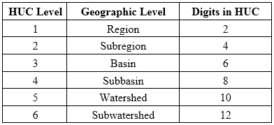
Source: USGS, Watershed Boundary Dataset (WBD) Facts
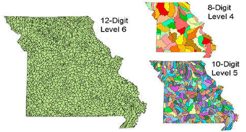
The following maps illustrate that codes with more digits correlate to smaller geographic areas. They color code Missouri’s eight-, 10- and 12-digit hydrologic units. Missouri has more than 65 subbasins, which have eight-digit hydrologic unit codes. However, the state has nearly 2,000 subwatersheds, which have 12-digit hydrologic unit codes.
Distribution of Missouri Level 4, Level 5 and Level 6 Hydrologic Units
Within an AgSite report, click “View map” beside the 12-Digit Hydrologic Units heading to generate a map that outlines surrounding 12-digit hydrologic units in the area, based on data from the USDA Natural Resources Conservation Service. Users may need to zoom out from their evaluation site to see different hydrologic units. The map contains the watershed name and boundary lines for the watersheds. By left mouse clicking on an area on the map, a table of attributes becomes visible.
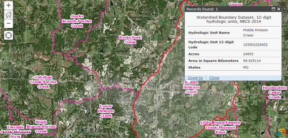
In the “Map Layers” window, users can choose to display various reference map features, such as place names, place boundaries, topographic features and satellite images. By selecting the “Tools” window, users may choose to “Query Data.” Using the drop-down menu, users may query the hydrologic unit data and search for a specific unit by name or code. The other data query options are for acres, area in square kilometers and states. After performing a data query that generates results, click “Show Attribute Table” to learn more about the searched hydrologic units. After a query has been run, users may hover over a given hydrologic unit to view its attributes. The following map, which was generated as a hydrologic unit data query, outlines subwatershed regions that surround Columbia, Mo. It identifies the Middle Hinkson Creek subwatershed as hydrologic unit 103001020602.
12-Digit Hydrologic Units Surrounding Columbia, Mo.
Watersheds occupy several important roles in local communities. Clean water from healthy watersheds provide drinking water and recreational opportunities, and aquatic life and other wildlife also rely on watersheds. Keeping watersheds healthy may blunt the effects of climate and land use changes, and they can reduce flood-related damages.
Educational Resources:
The U.S. Environmental Protection Agency offers an online training course that focuses on watershed management.
Sources and Other Resources:
- Missouri Department of Natural Resources, Watersheds
- U.S. Environmental Protection Agency, Healthy Watershed Protection
- USGS, Hydrologic Unit Maps
- USGS, Science in Your Watershed
Principal Aquifers
An aquifer is a geologic formation, a group of formations, or a part of a formation that contains sufficient saturated permeable material to yield significant quantities of water to wells and springs. The areal and vertical location of major aquifers is fundamental to the determination of groundwater availability for the U.S.
A principal aquifer is defined as a regionally extensive aquifer or aquifer system that has the potential to be used as a source of potable (drinkable) water. For study or mapping purposes, aquifers are often combined into aquifer systems.
For an overview of principal aquifers: The principal water-yielding aquifers of North America can be grouped into five types by rock type and location: